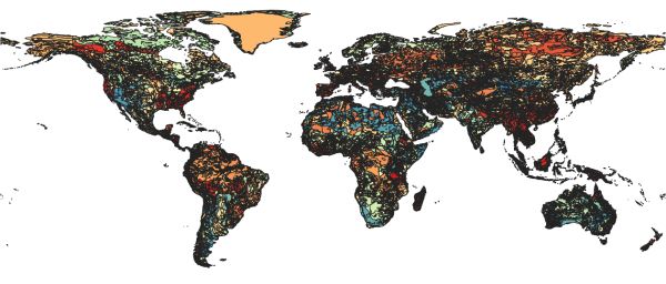
Digital Soil Map of the World
[Descripción] The vector data set is based on the FAO-UNESCO Soil Map of the World. The Digitized Soil Map of the World, at 1:5.000.000 scale,
[Autoría] FAO-UNESCO.
[Web original] https://data.apps.fao.org/map/catalog/srv/spa/catalog.search#/metadata/446ed430-8383-11db-b9b2-000d939bc5d8
[Formato] Vectorial; original: shapefile; local: geopackage.
[Resolución espacial / Escala] 1:5.000.000
[SRS] EPSG:4326
[Licencia] The user agrees to acknowledge the source of FAO data as follows: 'Source: Land and Water Development Division, FAO, Rome' in any public or commercial document or map or paper reproducing FAO data, or describing studies or computations based on the use of such data.
[Descarga en origen] https://storage.googleapis.com/fao-maps-catalog-data/uuid/446ed430-8383-11db-b9b2-000d939bc5d8/resources/DSMW.zip
[Descarga en local] v04_DSMW
[Observaciones] Metadatos completos en https://data.apps.fao.org/map/catalog/srv/api/records/446ed430-8383-11db-b9b2-000d939bc5d8/formatters/xml
La descarga incluye varios archivos auxiliares como texto y hojas de cálculo.
[Extensión geográfica]