ISLSCP II Global land cover classification
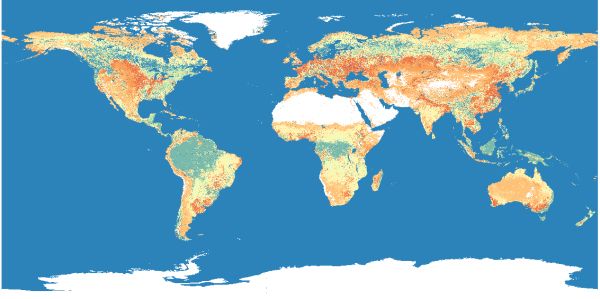
[Descripción] The data set describes the geographic distributions of 13 classes of vegetation cover (plus water and unclassified classes) based on a modified International Geosphere-Biosphere Programme (IGBP) legend. The data set also provides the fraction of each of the 15 classes within the coarser resolution cells. This data set provides global classified land cover grids at three spatial resolutions of 0.25, 0.5 and 1.0 degree in latitude and longitude.
[Autoría] DeFries, R.S. and M. Hansen, University of Maryland, Department of Geography.
[Web original] https://daac.ornl.gov/ISLSCP_II/guides/umd_landcover_xdeg.html
[Formato] Ráster; original: ascii; local: geotiff.
[Resolución espacial / Escala] 0.25º, 0.5º y 1.0º
[SRS] EPSG:4326
[Licencia] This dataset is openly shared, without restriction, in accordance with the EOSDIS Data Use Policy.
[Descarga en origen] https://daac.ornl.gov/cgi-bin/dsviewer.pl?ds_id=969 necesita registro en Earthdata.
[Descarga en local] N/A
[Observaciones] DeFries, R.S. and M. Hansen. 2010. ISLSCP II University of Maryland Global Land Cover Classifications, 1992-1993. In Hall, Forrest G., G. Collatz, B. Meeson, S. Los, E. Brown de Colstoun, and D. Landis (eds.). ISLSCP Initiative II Collection. Data set. Available on-line [http://daac.ornl.gov/] from Oak Ridge National Laboratory Distributed Active Archive Center, Oak Ridge, Tennessee, U.S.A. doi:10.3334/ORNLDAAC/969
[Extensión geográfica] Global.