Venus Magellan Global Topography 4641m v2
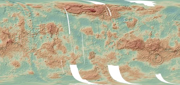
[Descripción] Version 2 (1997 release) of the Global Topographic Data Record (GTDR-SINUS.3;2). The range to surface is derived by fitting altimeter echoes from the fan-beam altimetry antenna as a function of time to Hagfors' radar backscatter model templates. The ranges are subtracted from the spacecraft radial coordinate (derived from Doppler tracking), yielding measurements of planetary radius. The data are filtered to remove low-frequency errors in the in-plane elements of each spacecraft orbit, and then originally re-sampled into sinusoidal, Mercator, and north and south polar stereographic projections at a resolution of 4641 meters per pixel.
[Autoría] Magellan Team.
[Web original] https://astrogeology.usgs.gov/search/map/Venus/Magellan/RadarProperties/Venus_Magellan_Topography_Global_4641m_v02.cub
[Formato] Ráster: geotiff.
[Resolución espacial / Escala] 4641 m.
[SRS] Simple Cylindrical Projection.
[Licencia] Public domain, please cite authors.
[Descarga en origen] https://planetarymaps.usgs.gov/mosaic/Venus_Magellan_Topography_Global_4641m_v02.tif
[Descarga en local] N/A
[Observaciones]
[Extensión geográfica] Minimum Latitude-90º; Maximum Latitude: 90º; Minimum Longitude: 0º; Maximum Longitude: 360º